A master MTB Trail plan for the Hobble Creek area has been in development for many years. In order to make this plan a reality we need support from concerned citizens and also cooperation from the City of Springville, the City of Mapleton, the Division of Wildlife Resources, and the United States Forest Service. As you may imagine, this is a huge undertaking to get so many individuals, municipalities, and governmental agencies to partnership in order to develop a cohesive trail plan.
Our plan is still in development and we hope to get continued approval from land managers and private property owners to make it a reality. Our desire is to make local citizens more aware of the Hobble Creek MTB Trail master plan in hopes to solicit help, create excitement, and build momentum to get the plan moving forward in the area. Below is a preliminary version of the master plan broken out into four phases.
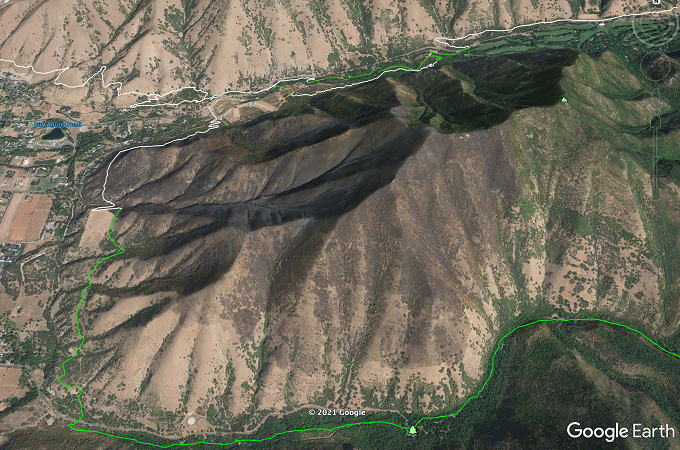
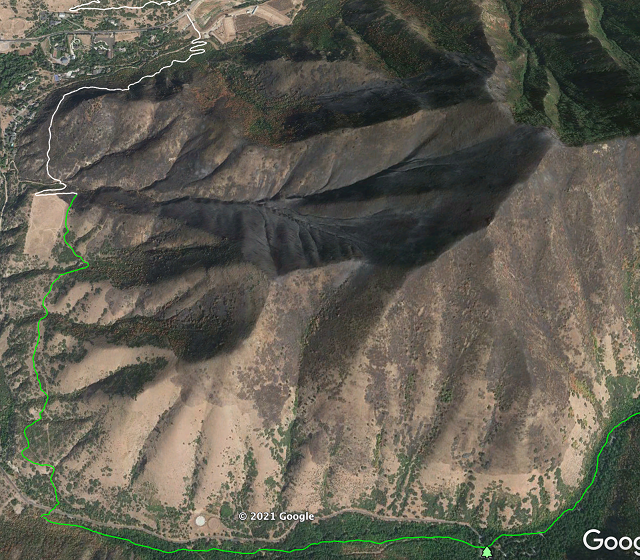
Overview: Hobble Creek Master Trail Plan
Status: In Development (Green: Existing Trail; White: Proposed Trail)
- Phase One: Create trailhead at base of Hobble Creek Canyon and short 1-mile loop
- Phase Two: Re-direct Bonneville Shoreline Trail (BST) and improve trail to Spring Creek Canyon
- Phase Three: Connect existing social trail up Hobble Creek Canyon in order to build single-track trail up the canyon
- Phase Four: Connect Hobble Creek Canyon to existing single-track trail up Maple Canyon
Phase One: Hobble Creek Canyon BST Trail head and short Hobble Creek Loop
Status: Complete
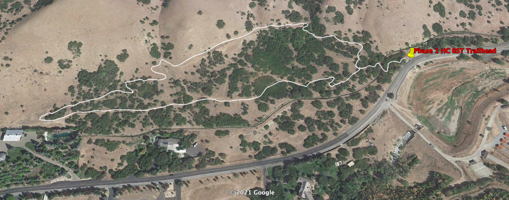
This section of trail at the base of Hobble Creek Canyon has been built and is rideable. The trail head for this short 1 mile loop is accessed at the dirt pull-out across the street to the North of the retention pond at the base of Hobble Creek Canyon. You can find the trail starting on the West end of the dirt parking lot, which is a short, twisty climb to the main loop. The loop can also be accessed from the culdesac on Stonebury Loop Road to the west of this map.
For more detailed information/instructions on this new Hobble Creek MTB Loop, please view this short video clip:
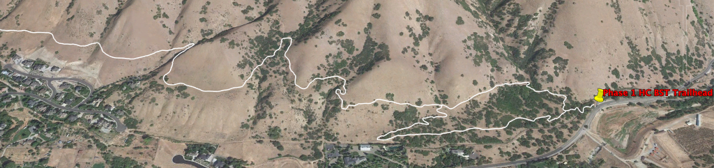
Phase Two: New BST trail to Spring Creek Canyon
Status: In design and seeking approval from land managers (DWR)
Now that we have completed the trailhead at the base of Hobble Creek Canyon and the short Hobble Creek Loop, the next phase will be to redirect the BST from the peak of our new loop over to Spring Creek Canyon. Currently, the BST continues north on a double track section of trail which ends into a cul-de-sac within a neighborhood in Springville. From that point you bike on the road within the neighborhood and have to pick up the BST at the other end of the neighborhood.
We would like to build the new BST to start at the peak of the small loop and climb to get up on a ridge and continue on to connect to the BST at Spring Creek Canyon. The current BST is either a dirt road (with two locked gates blocking bike traffic), a double-track trail, or paved streets that go through the neighborhood. The new proposed BST would be above the neighborhood and will be a single-track more traditional MTB trail. Please see graphic below for proposed route.
For more information on Phase 2, please view this short video:
Phase Three: Continuous single-track trail up Hobble Creek Canyon
Status: In design and seeking approval from the Forest Service
Hobble Creek has a number of segmented social trails in the canyon that could be connected in order to make a continuous single-track trail up the canyon ending at Rotary Centennial Park. Most of this land is owned/managed by the National Forest Service and we are currently seeking approval on this project.
In addition to all of the social trail that could be connected in the area, Springville City is seeking approval to build a possible MTB bike skills park on Forest Service land up the canyon. These plans are very preliminary and have yet to be approved.
For more information on the proposed trail up Hobble Creek Canyon, please view these videos:
Phase Four: Connect Hobble Creek Canyon and Maple Canyon (Whiting) with single-track trail
Status: In design and seeking approval from various land managers
The final phase of the Hobble Creek trail plan is to connect Hobble Creek Canyon and Maple Canyon via a single-track trail. This would be the last phase of our plan because, although very exciting, this will be most likely the most challenging to move forward on. It’s likely that this will take approval from the Forest Service, the City of Springville, and the City of Mapleton. In addition, there are many private land owners that would need to sign off on the plans.
Although this would be very difficult to manage, it would be an incredible addition to the recreational value to the community as mountain bikers, hikers, and equestrian users could access either canyon connected by good single-track trail. This could also help in fulfilling the 2021 bill in Congress proposed by Senator Romney and Representative Curtis of improvements to the Bonneville Shoreline Trail. Rather than the BST be splintered and stop in Springville, it could continue on to Mapleton and possibly further connecting into the Spanish Fork trail system by the reservoir.
What an amazing thing it would be to connect to trail in the Hobble Creek area and be able to ride, hike, or horse all the way up to Provo or down to Spanish Fork and also enjoy going up various canyons along the way!
For more information on Phase 4, please see this video: